
The aftermath of the July 2026 Assam floods is now entering an important recovery and rehabilitation phase, with government teams carrying out detailed damage assessments across some of the worst-affected districts of Upper Assam.
According to the Assam State Disaster Management Authority (ASDMA), the state continues to maintain dedicated flood reports and disaster-management resources, while its current web portal also lists a House Damage DBT Portal and other systems used for disaster reporting and assessment.
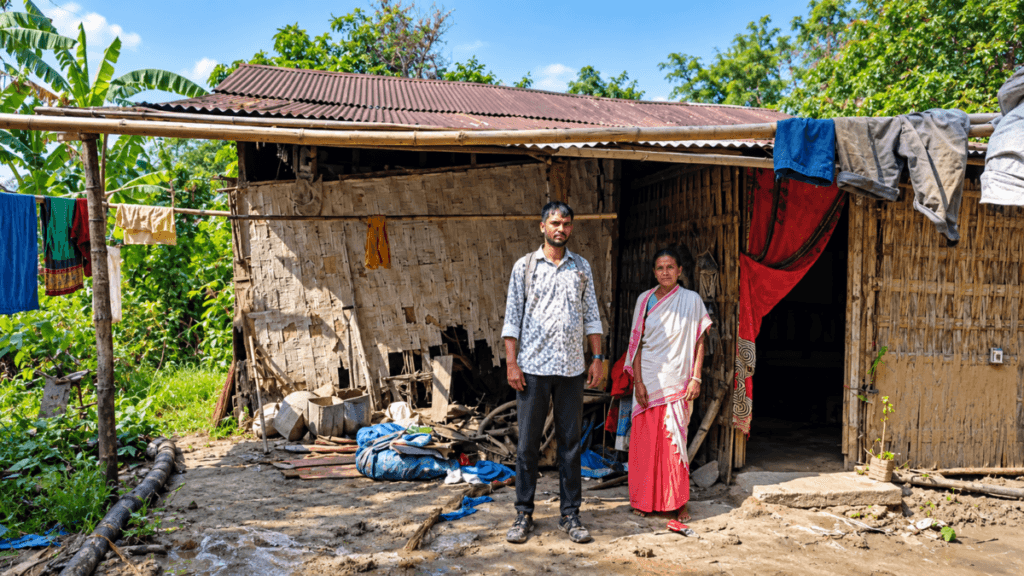
A recent field update from the Assam State Disaster Management Authority shows teams visiting flood-affected communities in Sivasagar, Charaideo, Jorhat and Golaghat. The photographs show officials speaking directly with residents and documenting damage to houses and household assets.
What Is the Rapid Damage Assessment Survey?
A rapid damage assessment is more than simply photographing flooded houses. Its purpose is to establish the nature and extent of damage so that relief, compensation and rehabilitation can be planned.
India’s disaster-management guidance identifies several areas that can be covered in rapid assessments, including damage to housing, roads, bridges, public buildings, utilities, crops and livestock. It also recognizes field reports, photographs, GPS/GIS information and other sources as useful assessment tools.
This makes the field photographs in the ASDMA update significant. They provide visual evidence of the conditions faced by individual households while survey teams collect information on the ground.
Four Upper Assam Districts Under Assessment
The second phase of the assessment covers:
- Sivasagar
- Charaideo
- Jorhat
- Golaghat
These districts experienced substantial impacts during the July flood episode.
In August, Assam Chief Minister Himanta Biswa Sarma said the floods had caused an estimated ₹480 crore in damage and affected 26,681 houses across the state. At that point, rapid damage assessment was underway in the four districts, with more than 1,000 surveyors deployed and approximately 75% of the assessment reported as completed.
The figures are important because the assessment process can continue to refine the understanding of losses. Initial estimates and subsequent household-level verification do not necessarily represent the same stage of information collection.
Sivasagar Records Extensive Household Damage
Sivasagar has been one of the major focus areas of the post-flood survey.
A district-level update reported in late August said that approximately 85% of the Rapid Damage Assessment Survey had been completed. The survey involved 574 surveyors and identified around 42,500 houses in the severe or complete-damage category in the assessment being conducted there.
The assessment was not limited to houses.
Survey teams were also examining losses involving:
- Handlooms
- Livestock
- Goats
- Pigs
- Ducks
- Poultry
- Other household and livelihood assets
This is particularly relevant in rural Assam, where a family’s economic security can depend on a combination of housing, agricultural activities, livestock and small household enterprises.
The Sivasagar administration also asked affected families who believed they had been missed by the assessment to contact survey teams or local representatives so their cases could be considered.
Why Household-Level Surveys Matter
Flood damage can look very different from one household to another.
One family may experience structural damage to a mud or bamboo house. Another may lose livestock, household goods, agricultural equipment or livelihood assets. Roads, drainage systems, schools and other public infrastructure can face a different category of damage.
Assam’s district disaster-management planning documents similarly describe damage assessment as covering lives, property, livestock, agriculture, houses and infrastructure such as roads, water supply and electricity. They also emphasize timely transmission of assessment information to facilitate assistance and rehabilitation.
Therefore, ground-level verification is an important part of converting a broad flood-impact estimate into household-level records.
What the Photographs Reveal
The images accompanying the ASDMA field update show survey personnel interacting with residents outside and inside homes.
Visible locations include areas identified in the photographs as Ujankuri Gaon, Kopohuating and Chariali in Assam.
Several houses appear to have traditional or semi-permanent construction, including walls made from locally used materials and corrugated metal roofing. Such structures can be particularly important to document after prolonged flooding because visible damage may include weakened walls, deterioration of building materials, damaged household belongings and disruption to normal living conditions.
The images should not, however, be treated as a complete measurement of damage. They are visual snapshots from particular locations. The formal assessment depends on the information collected by authorized survey teams and the applicable government assessment procedures.
Relief and Rehabilitation After the Survey
Damage assessment is closely connected with the next stages of disaster recovery.
In August, the Assam government reported that 96,842 flood-affected families had received ₹15,000 each as financial assistance, with ₹146.26 crore reported as disbursed at that stage. The government also discussed restoration of schools and Anganwadi centres, infrastructure repair, health camps, insurance claims and other forms of support.
ASDMA’s current website also lists specific 2026 procedures for repairing flood-damaged Anganwadi centres and government schools, alongside broader disaster-recovery and debris-management guidelines.
This illustrates an important point: flood recovery does not end when the water recedes. It involves documentation, financial assistance, rebuilding, restoration of essential services and support for affected livelihoods.
Digital Technology in Assam Flood Damage Assessment
Assam has also developed digital infrastructure for disaster management.
ASDMA lists several online systems, including the Disaster Reporting and Information Management System (DRIMS), a GIS portal, the Flood Preparedness & Score Card system and a House Damage DBT Portal for damage assessment.
At the national level, India’s National Disaster Management Information System is designed to capture disaster damage and losses and monitor the disbursement and utilization of disaster-management funds.
Combining field verification with digital records can help authorities organize large volumes of information from multiple villages and districts.
What Happens After Damage Assessment?
The assessment process can help establish which households and assets require assistance and what kind of restoration is necessary.
For affected families, the practical issues may include:
- Verification of household damage.
- Recording of eligible losses.
- Processing of financial assistance.
- Restoration of damaged homes and infrastructure.
- Repair of roads, schools and public facilities.
- Support for affected livelihoods.
- Health and sanitation measures after flooding.
- Follow-up assessments where discrepancies or complaints arise.
The assessment therefore forms a bridge between emergency response and long-term recovery.
Assam Flood 2026: A Continuing Recovery Story
The photographs from Sivasagar, Charaideo, Jorhat and Golaghat provide a ground-level view of a much larger disaster-management operation.
The official ASDMA platform continues to publish flood information and disaster-management resources, while district administrations are involved in local assessment and recovery activities.
For residents whose homes, livelihoods or assets were affected, accurate documentation remains particularly important. The quality of the assessment can influence how effectively authorities understand the scale and type of damage and plan subsequent assistance.
The Assam Flood 2026 response is therefore not only about the immediate flood emergency. It is also about documenting losses, restoring essential services and helping affected communities move from emergency conditions toward recovery.
As the Rapid Damage Assessment Survey progresses across Upper Assam, the field-level documentation from villages and households will remain an important part of understanding the full impact of the July floods.
Sources
- Assam State Disaster Management Authority — flood reports and disaster-management resources.
- ASDMA web services, including DRIMS and the House Damage DBT Portal.
- Ministry of Home Affairs/NDM India guidance on rapid damage assessment.
- Reporting on the 2026 Assam flood damage assessment and relief figures.